
Macau’s Meteorological and Geophysical Bureau (SMG) issued Typhoon Signal No. 1 at 3 pm today as Super Typhoon Ragasa began to affect Macau and the surrounding areas, with the bureau warning everyone in Macau that it may have impact “comparable” to that of Typhoons Hato (2017) and Mangkhut (2018).
In addition, the current signal will be replaced by signal no. 3 between midnight and early morning tomorrow (23 September).
Meanwhile, the neighbouring Hong Kong SAR’s observatory already announced it will issue signal no. 3 at 9:40 pm tonight. The Hong Kong Observatory (HKO) will also consider issuing the city’s Gale or Storm Signal No. 8 between 1 and 4 pm tomorrow, according to its website.
SMG has pointed out on its website there is a “high” possibility that Macau will issue Typhoon Signal No. 8 between afternoon and the evening tomorrow (23 September).
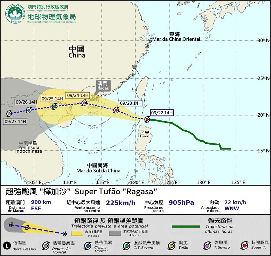
According to the bureau, at 2 pm, Ragasa was estimated to be about 900km east-southeast of Macau and was forecast to move west-northwest at around 22km/h moving across the Bashi Channel.
Due to its broad circulation and the combined influence of the northeast monsoon, winds in Macau are forecast to strengthen significantly later tomorrow.
Based on the current forecast track, the super typhoon is expected to approach the Pearl River Estuary closely between the early hours and morning on Wednesday (24 September), potentially passing within 100 kilometres of Macau, with winds predicted to reach force 12 or above for an extended period of time – accompanied by persistent heavy rain, thunderstorms and gusty winds.
Residents living on high floors have been warned to prepare for “severe” impacts from hurricane-force winds or higher, with significant storm surge also expected. If this coincides with the astronomical high tide, storm surge flooding like that of the times of Hato and Mangkhut may occur during daytime on Wednesday, according to SMG.
Meanwhile, the local government has advised the people in Macau to prepare essential emergency supplies, including three days’ worth of water and food, torches, medicines and first-aid items, as well as to pay attention to evacuation routes in case of emergency.
Moreover, everyone is advised to charge their mobile phones and other electronic devices in advance to stay informed about the latest updates on the typhoon and emergency information.
The government has also advised the public to avoid using underground passageways and parking garages in areas affected by flooding.
Additionally, Macau Electricity Company (CEM) has said it will take the initiative to suspend power supply in low-lying areas based on the flooding condition in order to ensure personal and property safety of the people in Macau, as well as to avoid damage to power facilities and speed up power restoration after the water has receded. More information can be found on CEM’s website or Facebook page.
Furthermore, all early childhood institutions as well as all primary and secondary schools in Macau will be suspended tomorrow and on Wednesday, the Education and Youth Development Bureau (DSEDJ) has announced.
The public is advised to closely monitor Macau’s latest weather updates issued by local authorities as uncertainty remains regarding Ragasa’s trajectory and moving speed. – GNM
Source and Image: SMG

COMMENTS